
GIVE THE PERFECT GIFT
Erin Mills Town Centre Gift Cards are the perfect choice for your gift giving needs.Purchase gift cards at kiosks near the food court or centre court, at Guest Services, or click below to purchase online.PURCHASE HEREHome
Aerial Atlas of Ancient Britain
Indigo
Loading Inventory...
Aerial Atlas of Ancient Britain
Current price: $60.00

Aerial Atlas of Ancient Britain
Current price: $60.00
Loading Inventory...
Size: Hardcover
*Product information may vary - to confirm product availability, pricing, shipping and return information please contact Indigo
A spectacular and
mesmerizing collection of
aerial photographs of
Britain’s most extraordinary
prehistoric sites.
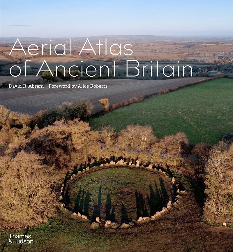
Drawing on years of travel around Britain’s most extraordinary prehistoric sites, David Abram’s aerial photographs reveal the ancient wonders hiding in plain sight around the country, from Neolithic tombs on the Wessex chalklands to Iron Age crannogs in Hebridean lochs. Breathtaking photos reveal Neolithic enclosures, cairns, and stone circles; Bronze Age villages, farmsteads, tombs, and burial mounds; and Iron Age hillforts, all captured in spectacular bird’s-eye-view detail. Stone cairns and circles evoke lost rituals and religious ceremonies; Iron Age ramparts hint at former strongholds; and tangible geographical clues reveal the scars of real or mythical battles.
The eye-in-the-sky perspective unveils both the unseen forms of these ancestral monuments as well as their relationship to their wider landscapes, capturing subtle symmetries and forgotten sight lines. Many of Abram’s images have an abstract quality that momentarily disrupts one’s sense of perspective, allowing the shapes carved thousands of years ago to evoke an emotional resonance—an experience at once pleasurable and instructive. This is an inspiring way to discover the beauty and history of the British landscape, revealing the visible traces of our ancestors, from such famous monuments as Stonehenge to little-known gems that have never before been seen from the air.
A spectacular and
mesmerizing collection of
aerial photographs of
Britain’s most extraordinary
prehistoric sites.
Drawing on years of travel around Britain’s most extraordinary prehistoric sites, David Abram’s aerial photographs reveal the ancient wonders hiding in plain sight around the country, from Neolithic tombs on the Wessex chalklands to Iron Age crannogs in Hebridean lochs. Breathtaking photos reveal Neolithic enclosures, cairns, and stone circles; Bronze Age villages, farmsteads, tombs, and burial mounds; and Iron Age hillforts, all captured in spectacular bird’s-eye-view detail. Stone cairns and circles evoke lost rituals and religious ceremonies; Iron Age ramparts hint at former strongholds; and tangible geographical clues reveal the scars of real or mythical battles.
The eye-in-the-sky perspective unveils both the unseen forms of these ancestral monuments as well as their relationship to their wider landscapes, capturing subtle symmetries and forgotten sight lines. Many of Abram’s images have an abstract quality that momentarily disrupts one’s sense of perspective, allowing the shapes carved thousands of years ago to evoke an emotional resonance—an experience at once pleasurable and instructive. This is an inspiring way to discover the beauty and history of the British landscape, revealing the visible traces of our ancestors, from such famous monuments as Stonehenge to little-known gems that have never before been seen from the air.
You May Also Like


![An Atlas of Antient [I.E. Ancient] Geography](https://cdn.mall.adeptmind.ai/https%253A%252F%252Fcdn.shopify.com%252Fs%252Ffiles%252F1%252F0655%252F8980%252F5233%252Ffiles%252F1_f0068cd8-3142-433a-84d5-07c0a81f71f4.jpg_medium.webp)








More About Indigo at Erin Mills Town Centre
The largest book retailer in Canada also offers toys, music, home décor, gifts and lifestyle products. What's Inside...Books, Magazines, CD’s and DVD’s, Toys and Gifts, Home Accents, Electronics, Baby’s and Children’s Section, Bath and Body, Kitchen and Bedroom, Stationary Located outside in the exterior plaza.
5015 Glen Erin Dr, Mississauga, ON L5M 0R7, Canada
Find Indigo at Erin Mills Town Centre in Mississauga ON
Visit Indigo at Erin Mills Town Centre in Mississauga ON