Home
Regina Saskatoon Communities Atlas
Walmart
Loading Inventory...
Regina Saskatoon Communities Atlas
From MapArt
Current price: $19.95
From MapArt
Regina Saskatoon Communities Atlas
Current price: $19.95
Loading Inventory...
*Product information may vary - to confirm product availability, pricing, shipping and return information please contact Walmart
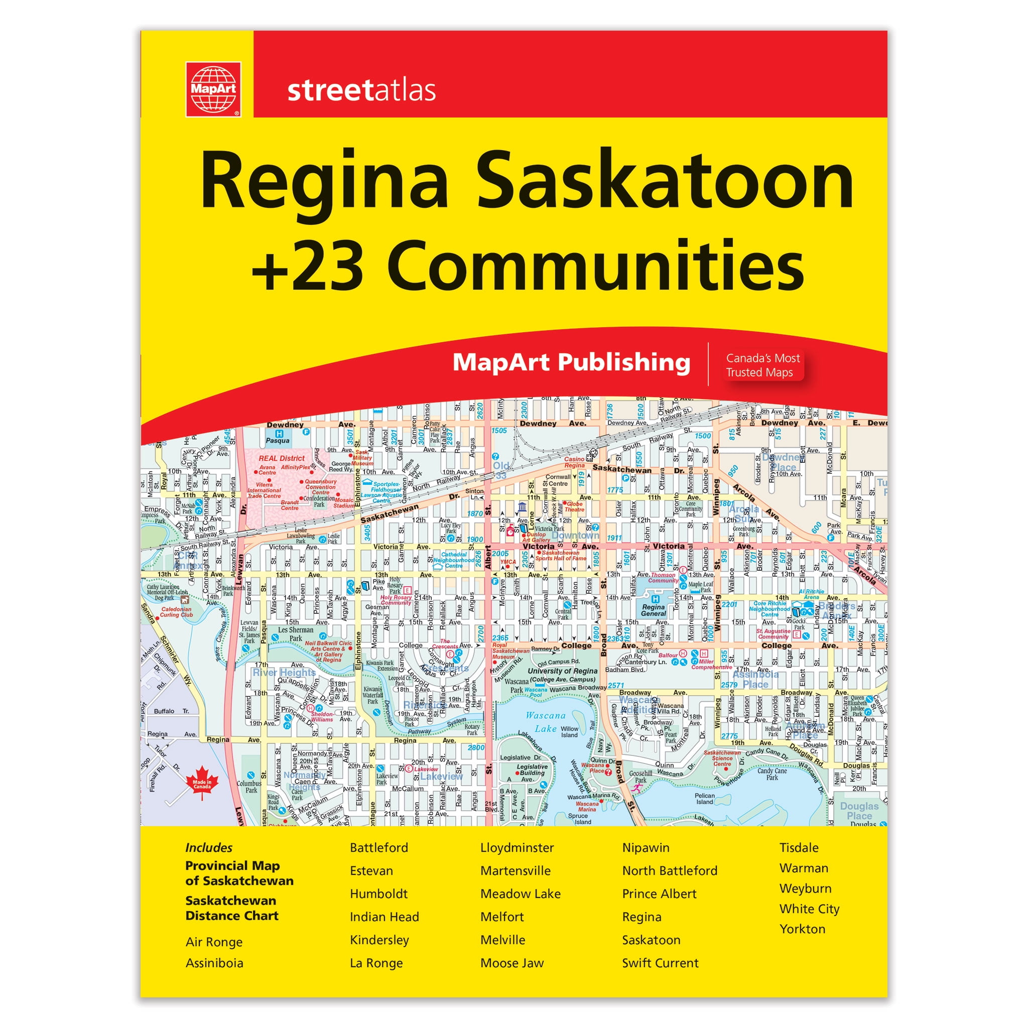
Regina Saskatoon Communities Atlas - 607 It’s the definitive auto companion for travel in this area, whether you are a resident or short-term visitor. It’s got all the features to make even the unfamiliar areas easy to navigate. Inside this 64 page atlas you will find city maps (1:25,000), Saskatchewan Provincial Map (1:1,500,000), locator maps, Saskatchewan distance chart and street indexes. City mapping includes Air Ronge, Assiniboia, Battleford, Estevan, Humboldt, Indian Head, Kindersley, La Ronge, Lloydminster, Martensville, Meadow Lake, Melfort, Melville, Moose Jaw, Nipawin, North Battleford, Prince Albert, Regina, Saskatoon, Swift Current, Tisdale, Warman, Weyburn, White City and Yorkton?. The detailed city maps features include divided highways, major roads, secondary roads, main thoroughfares, minor streets, lanes / private streets, interchange numbers, one way streets, street address numbers, Trans-Canada Highway, Yellowhead Route, railways, VIA Rail stations, provincial boundaries, municipal boundaries, recreation trails, parks / conservation areas, golf courses, commercial areas, cemeteries, institutional areas, industrial areas, special attraction areas, Indian Reserves, hospitals, tourist information centres, police stations, fire halls, municipal / regional buildings, courthouses, libraries, points of interest, off leash dog parks, casinos, national parks / historic sites, arenas, community / recreation centres, pools, baseball, soccer, tennis, skiing, campgrounds, public school and catholic schools. Saddlestitched bound Dimensions: 21 x 28 cm (8.375 x 10.875 inches) Proudly made in Canada! Provinces/Territories: Saskatchewan
Regina Saskatoon Communities Atlas - 607 It’s the definitive auto companion for travel in this area, whether you are a resident or short-term visitor. It’s got all the features to make even the unfamiliar areas easy to navigate. Inside this 64 page atlas you will find city maps (1:25,000), Saskatchewan Provincial Map (1:1,500,000), locator maps, Saskatchewan distance chart and street indexes. City mapping includes Air Ronge, Assiniboia, Battleford, Estevan, Humboldt, Indian Head, Kindersley, La Ronge, Lloydminster, Martensville, Meadow Lake, Melfort, Melville, Moose Jaw, Nipawin, North Battleford, Prince Albert, Regina, Saskatoon, Swift Current, Tisdale, Warman, Weyburn, White City and Yorkton?. The detailed city maps features include divided highways, major roads, secondary roads, main thoroughfares, minor streets, lanes / private streets, interchange numbers, one way streets, street address numbers, Trans-Canada Highway, Yellowhead Route, railways, VIA Rail stations, provincial boundaries, municipal boundaries, recreation trails, parks / conservation areas, golf courses, commercial areas, cemeteries, institutional areas, industrial areas, special attraction areas, Indian Reserves, hospitals, tourist information centres, police stations, fire halls, municipal / regional buildings, courthouses, libraries, points of interest, off leash dog parks, casinos, national parks / historic sites, arenas, community / recreation centres, pools, baseball, soccer, tennis, skiing, campgrounds, public school and catholic schools. Saddlestitched bound Dimensions: 21 x 28 cm (8.375 x 10.875 inches) Proudly made in Canada! Provinces/Territories: Saskatchewan
![Saskatoon Saskatchewan Western Canada [microform] by Saskatoon Board of Trade, Hardcover | Indigo Chapters](https://dynamic.indigoimages.ca/books/9781020520501.jpg?scaleup=true&width=600&quality=85&lang=en)